 By Saurav Mehra
 Mhatre Bridge, officially known as Vitthalrao Gadgil Bridge, is one of the busiest and most important road bridges in Pune, Maharashtra. Built across the Mutha River, the bridge connects Deccan Gymkhana and Erandwane with areas like Karvenagar, Kothrud, and Sinhagad Road. Because of its central location and heavy traffic movement, Mhatre Bridge has become one of Pune’s major transportation landmarks.
Locally, most residents still call it “Mhatre Bridge,” and the surrounding junction is one of the city’s busiest commuter corridors. The bridge is widely used by office-goers, students, buses, and two-wheelers traveling between western Pune and central city areas.
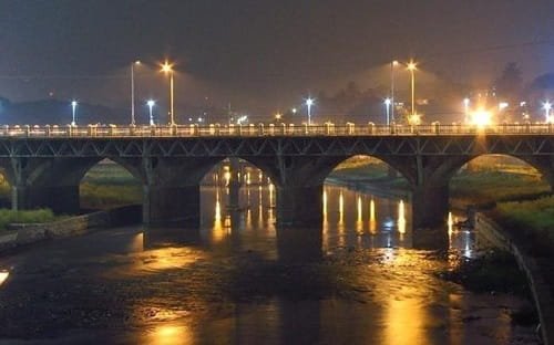
| Feature | Details |
| Popular Name | Mhatre Bridge |
| Official Name | Vitthalrao Gadgil Bridge |
| Location | Pune, Maharashtra |
| State | Maharashtra |
| River | Mutha River |
| Bridge Type | Urban road bridge |
| Famous For | Major west Pune connectivity |
| Nearby Areas | Deccan, Erandwane, Karvenagar, Kothrud |
| Nearest Railway Station | Pune Junction |
| Nearest Metro Station | Vanaz Metro Station |
| Nearest Airport | Pune International Airport |
| Main Purpose | Urban traffic connectivity |
Location of Mhatre Bridge
Mhatre Bridge is located in central-west Pune across the Mutha River. The bridge connects Deccan Gymkhana and Erandwane on one side with Karvenagar and Kothrud on the other side. (en.wikipedia.org)
The bridge also provides important connectivity toward Sinhagad Road and other residential suburbs in western Pune.
Directions to Reach Mhatre Bridge
Reaching Mhatre Bridge is easy because the area has strong road, bus, and metro connectivity.
By Road
Travelers can reach the bridge through:
- Karve Road
- Paud Road
- Deccan Gymkhana routes
- Sinhagad Road
PMPML buses, taxis, auto-rickshaws, and private vehicles regularly use the bridge corridor.
By Metro
Vanaz Metro Station and nearby Pune Metro routes provide access toward the bridge area.
By Train
Pune Junction is the nearest major railway station connected through city roads.
By Air
Pune International Airport is the nearest airport accessible through city traffic routes.
History of Mhatre Bridge
Mhatre Bridge was constructed to improve transportation between western Pune suburbs and central Pune city. As Pune expanded rapidly after the 1970s and 1980s, traffic pressure increased on older bridges across the Mutha River. (en.wikipedia.org)
The bridge was officially named after Vitthalrao Gadgil, a senior Congress leader and freedom fighter from Maharashtra. However, local residents continued using the older and more familiar name “Mhatre Bridge.”
Over time, the bridge became one of Pune’s busiest daily commuter routes because it connected fast-growing residential areas like Kothrud and Karvenagar with central business zones.
Structure and Design of Mhatre Bridge
Mhatre Bridge is designed as a multi-lane urban road bridge supporting heavy daily traffic movement.
Important features include:
- Multi-lane roadway
- River crossing structure
- Public transport movement
- Pedestrian access
- Integration with major Pune roads
The bridge supports both local traffic and inter-area commuter movement.
Importance of Mhatre Bridge
Mhatre Bridge plays a major role in Pune’s urban transportation network.
The bridge helps connect:
- Deccan Gymkhana
- Erandwane
- Karvenagar
- Kothrud
- Sinhagad Road routes
Thousands of commuters use the bridge daily for office travel, college access, business transportation, and city movement. (punemirror.com)
Nearby Areas Around Mhatre Bridge
Deccan Gymkhana
Deccan Gymkhana is one of Pune’s oldest educational and commercial areas known for colleges, restaurants, and shopping.
Erandwane
Erandwane is a major residential and educational locality located near the bridge.
Karvenagar
Karvenagar is one of western Pune’s important residential suburbs connected through the bridge route.
Kothrud
Kothrud is one of Pune’s largest residential areas and a major traffic source for the bridge corridor.
Sinhagad Road
Sinhagad Road connects eastern and southern Pune suburbs through nearby bridge routes.
Traffic Situation at Mhatre Bridge
Mhatre Bridge experiences heavy traffic congestion throughout the day because it connects several major residential and commercial zones.
Traffic usually increases during:
- Morning office hours
- Evening rush hours
- College timings
- Festival seasons
The bridge is especially crowded with two-wheelers, buses, and office commuters during peak hours. (punemirror.com)
Infrastructure and Traffic Improvement Plans
Pune authorities have proposed multiple traffic improvement measures near Mhatre Bridge over the years.
These include:
- Junction redesign
- Traffic signal improvements
- Metro connectivity expansion
- Road widening projects
- Smart traffic management systems
Recent Pune Metro developments also improved transportation options near western Pune corridors.
Flood and Monsoon Concerns
Because the bridge is built across the Mutha River, water levels sometimes rise during heavy monsoon rainfall and dam water releases.
Authorities regularly monitor river conditions during:
- Heavy rain periods
- Khadakwasla dam releases
- Monsoon flooding alerts
Despite these concerns, the bridge remains one of Pune’s critical transport links.
Public Transport Connectivity
Mhatre Bridge is an important PMPML bus corridor connecting western Pune with central city areas.
The area has:
- Frequent city bus services
- Auto-rickshaw availability
- Metro access through nearby stations
- Strong road connectivity
This makes the bridge an important daily commuting route for students and office workers.
Nearby Attractions Around Mhatre Bridge
Deccan Gymkhana Market
A popular shopping and food destination in Pune.
Saras Baug
One of Pune’s famous gardens and temple attractions.
Pune-Okayama Friendship Garden
A Japanese-style garden located near Sinhagad Road routes.
Film and Television Institute of India (FTII)
A famous film institute located near Deccan areas.
Interesting Facts About Mhatre Bridge
- The official name is Vitthalrao Gadgil Bridge. (en.wikipedia.org)
- Most Pune residents still call it Mhatre Bridge.
- The bridge connects western Pune suburbs with central city areas.
- It is one of Pune’s busiest commuter bridges.
- The bridge crosses the Mutha River in Pune.
Conclusion
Mhatre Bridge is one of Pune’s most important transportation corridors connecting Deccan, Erandwane, Kothrud, and Karvenagar across the Mutha River. Because of its strategic location and strong connectivity, the bridge handles massive daily commuter traffic and remains a vital part of Pune’s urban infrastructure.
Its importance continues to grow as western Pune expands with new residential and commercial developments.
FAQs About Mhatre Bridge
Q1. Where is Mhatre Bridge located?
Mhatre Bridge is located across the Mutha River in Pune, Maharashtra. (en.wikipedia.org)
Q2. What is the official name of Mhatre Bridge?
The official name is Vitthalrao Gadgil Bridge. (en.wikipedia.org)
Q3. Why is Mhatre Bridge famous?
The bridge is famous for connecting western Pune suburbs with central Pune city areas.
Q4. Which river flows below Mhatre Bridge?
The Mutha River flows below the bridge.
Q5. Which areas are connected by Mhatre Bridge?
The bridge connects Deccan, Erandwane, Karvenagar, Kothrud, and nearby areas.
Q6. Why is traffic heavy at Mhatre Bridge?
Traffic is heavy because thousands of commuters use the bridge daily for office and college travel. (punemirror.com)
Q7. Which metro station is nearest to Mhatre Bridge?
Vanaz Metro Station is one of the nearest metro stations.
Q8. Which railway station is nearest to Mhatre Bridge?
Pune Junction is the nearest major railway station.
Q9. Is Mhatre Bridge important for Pune traffic?
Yes, it is one of Pune’s major commuter and transport bridges.
Q10. What are the nearby attractions near Mhatre Bridge?
Nearby attractions include Saras Baug, Deccan Gymkhana, FTII, and Pune-Okayama Friendship Garden.