 By Saurav Mehra
Dhola–Sadiya Bridge, officially known as Bhupen Hazarika Setu, is one of India’s most important river bridges and among the longest bridges over water in the country. Built across the Lohit River, a major tributary of the Brahmaputra, the bridge connects Assam with Arunachal Pradesh and plays a major role in transportation and strategic connectivity in Northeast India.
The bridge is famous for its massive 9.15-kilometer length, military importance, and its role in reducing travel time between Assam and Arunachal Pradesh. Opened in 2017, the bridge has transformed connectivity in the eastern part of the Northeast region.
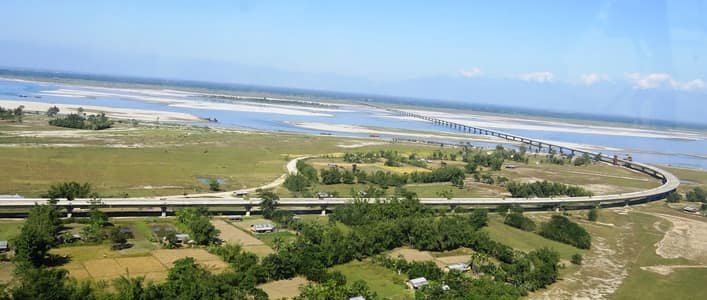
| Feature | Details |
| Official Name | Bhupen Hazarika Setu |
| Popular Name | Dhola–Sadiya Bridge |
| Location | Tinsukia district, Assam |
| States Connected | Assam and Arunachal Pradesh |
| River | Lohit River |
| Opened In | 2017 |
| Bridge Type | Beam bridge |
| Total Length | Around 9.15 km |
| Famous For | One of India’s longest river bridges |
| Nearby Areas | Dhola, Sadiya, Tinsukia |
| Nearest Railway Station | Tinsukia Junction |
| Main Purpose | Regional and strategic connectivity |
Location of Dhola–Sadiya Bridge
Dhola–Sadiya Bridge is located in the Tinsukia district of Assam. The bridge stretches from Dhola in southern Assam toward Sadiya in the north and provides road connectivity toward Arunachal Pradesh.
The bridge crosses the Lohit River, which later joins the Brahmaputra River system.
Directions to Reach Dhola–Sadiya Bridge
Reaching the bridge is possible through roads, railways, and nearby airports in Upper Assam.
By Road
Travelers can reach the bridge through highways connecting Tinsukia, Dibrugarh, and eastern Assam regions using buses, taxis, or private vehicles.
By Train
Tinsukia Junction is the nearest major railway station connected to Guwahati, Dibrugarh, and other major Indian cities.
By Air
Dibrugarh Airport is the nearest major airport connected through road transport toward Dhola and Sadiya regions.
History of Dhola–Sadiya Bridge
The idea for the bridge was proposed to improve transportation in Northeast India and strengthen strategic connectivity near the India–China border region. Feasibility studies reportedly began in 2003, while the project received approval in 2009.
Construction started in November 2011 under the Ministry of Road Transport and Highways. After years of construction work, the bridge was inaugurated on 26 May 2017 by Prime Minister Narendra Modi.
The bridge was officially named after legendary Assamese singer and cultural icon Dr. Bhupen Hazarika.
Structure and Design of Dhola–Sadiya Bridge
Dhola–Sadiya Bridge is a beam bridge constructed using reinforced concrete and modern bridge engineering techniques.
Important features include:
- Approximate length of 9.15 km
- Width of around 12.9 meters
- 183 spans
- Heavy military load capacity
- Earthquake-resistant design
The bridge was specially designed to support heavy military vehicles including Indian Army battle tanks.
Importance of Dhola–Sadiya Bridge
The bridge plays a major role in Northeast India’s transportation system.
The bridge helps:
- Connect Assam and Arunachal Pradesh
- Reduce travel time by several hours
- Improve defense logistics
- Improve trade and tourism
- Support regional economic growth
Its strategic importance increased because of its location near the India–China border region.
Nearby Areas Around Dhola–Sadiya Bridge
Dhola
Dhola is the southern end of the bridge located in Tinsukia district of Assam.
Sadiya
Sadiya is a historic town in Assam known for its cultural and historical importance.
Tinsukia
Tinsukia is one of Upper Assam’s important commercial and transportation centers.
Arunachal Pradesh Border Routes
The bridge improves road access toward eastern Arunachal Pradesh and nearby border regions.
Strategic Importance of the Bridge
Dhola–Sadiya Bridge is considered strategically important for India because it allows faster military movement toward border regions in Arunachal Pradesh.
The bridge was reportedly designed to support:
- 60-ton battle tanks
- Heavy military transport vehicles
- Emergency logistics movement
Its construction significantly improved infrastructure in India’s Northeast frontier region.
Traffic and Connectivity Benefits
Before the bridge was built, transportation between Assam and Arunachal Pradesh depended heavily on ferries and long detours.
The bridge now helps:
- Reduce travel time
- Improve year-round transportation
- Improve regional trade
- Boost tourism
Recent reports suggest the bridge has increased tourism and business activities between Assam and Arunachal Pradesh.
Tourist Attraction and Scenic Beauty
Dhola–Sadiya Bridge attracts visitors because of:
- Massive bridge length
- River scenery
- Sunrise and sunset views
- Northeast road trip routes
- Engineering beauty
Driving across the bridge offers panoramic views of the Lohit River and surrounding landscapes.
Interesting Facts About Dhola–Sadiya Bridge
- It is officially called Bhupen Hazarika Setu.
- The bridge is around 9.15 km long.
- It connects Assam with Arunachal Pradesh.
- The bridge was inaugurated in 2017.
- It was built to handle heavy military tanks and vehicles.
Conclusion
Dhola–Sadiya Bridge is one of India’s greatest infrastructure achievements in Northeast India. Built across the Lohit River in Assam, the bridge has transformed transportation, tourism, trade, and strategic connectivity between Assam and Arunachal Pradesh.
Its massive scale, engineering importance, and strategic role continue to make Bhupen Hazarika Setu one of the most important bridges in India.
FAQs About Dhola–Sadiya Bridge
Q1. Where is Dhola–Sadiya Bridge located?
The bridge is located in Tinsukia district of Assam across the Lohit River.
Q2. What is the official name of Dhola–Sadiya Bridge?
The official name is Bhupen Hazarika Setu.
Q3. Why is Dhola–Sadiya Bridge famous?
The bridge is famous for being one of India’s longest bridges over water and for connecting Assam with Arunachal Pradesh.
Q4. Which river flows below Dhola–Sadiya Bridge?
The Lohit River flows below the bridge.
Q5. How long is Dhola–Sadiya Bridge?
The bridge is around 9.15 kilometers long.
Q6. When was Dhola–Sadiya Bridge inaugurated?
The bridge was inaugurated on 26 May 2017.
Q7. Which states are connected by the bridge?
The bridge connects Assam and Arunachal Pradesh.
Q8. Why is the bridge strategically important?
The bridge improves military and transport connectivity near the India–China border region.
Q9. Which railway station is nearest to the bridge?
Tinsukia Junction is the nearest major railway station.
Q10. Which airport is nearest to Dhola–Sadiya Bridge?
Dibrugarh Airport is the nearest major airport.
 Akash Sharma