 By Akash Sharma
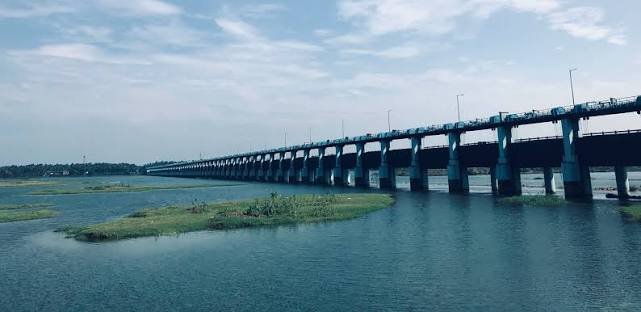
Chamravattom Bridge is one of Kerala’s major river bridges built across the Bharathapuzha River in Malappuram district. Located near Ponnani and Tirur regions, the bridge significantly improved road connectivity between different parts of Malappuram and nearby districts. The bridge is widely known for its modern design, scenic river views, and recurring flooding discussions during monsoon seasons.
The bridge became an important transportation link after replacing older ferry and narrow crossing systems across the Bharathapuzha River, which is Kerala’s second-longest river. Today, Chamravattom Bridge is considered one of the major infrastructure landmarks in Malappuram district.
Quick Overview of Chamravattom Bridge
| Feature | Details |
| Popular Name | Chamravattom Bridge |
| Location | Malappuram district, Kerala |
| State | Kerala |
| River | Bharathapuzha River |
| Bridge Type | Road bridge |
| Opened In | 2012 |
| Famous For | Bharathapuzha crossing and scenic views |
| Nearby Areas | Ponnani, Tirur, Edappal |
| Nearest Railway Station | Tirur Railway Station |
| Nearest Airport | Calicut International Airport |
| Main Roads Connected | Ponnani–Tirur Road |
| Main Purpose | Transportation and regional connectivity |
Location of Chamravattom Bridge
Chamravattom Bridge is located across the Bharathapuzha River near Chamravattom village in Malappuram district, Kerala. The bridge lies close to the Ponnani–Tirur route and acts as an important regional connector.
The bridge area is connected with:
- Ponnani
- Tirur
- Edappal
- Kuttippuram
- Coastal Malappuram regions
Its location makes it an important transportation link in central Kerala.
Directions to Reach Chamravattom Bridge
Reaching Chamravattom Bridge is easy through road, railway, and airport connectivity.
By Road
Travelers can reach the bridge through:
- Ponnani–Tirur Road
- NH-66 connectivity routes
- Malappuram district roads
- Edappal road corridor
KSRTC buses, taxis, auto-rickshaws, and private vehicles regularly travel through the bridge route.
By Train
Tirur Railway Station is the nearest major railway station connected to Kerala’s railway network.
By Air
Calicut International Airport is the nearest airport connected through Malappuram road routes.
History of Chamravattom Bridge
Before the bridge was built, crossing the Bharathapuzha River in this region was more difficult and time-consuming. Local residents often depended on ferries or longer alternative routes. The Kerala government later approved the bridge project to improve transportation and regional development in Malappuram district.
Construction reportedly started during the 2000s, and the bridge was officially opened to the public in May 2012. (en.wikipedia.org)
After opening, the bridge significantly reduced travel time between Ponnani and Tirur areas.
Structure and Design of Chamravattom Bridge
Chamravattom Bridge is designed as a long multi-span concrete roadway bridge across the Bharathapuzha River.
Important features include:
- Reinforced concrete structure
- Multi-span bridge design
- Elevated roadway
- Wide traffic lanes
- River-crossing infrastructure
According to reports:
- The bridge is approximately 978 meters long
- Width is around 10.5 meters
(en.wikipedia.org)
The bridge was designed to improve transportation while supporting heavy regional traffic movement.
Importance of Chamravattom Bridge
Chamravattom Bridge plays a major role in transportation across central Kerala.
The bridge helps connect:
- Ponnani
- Tirur
- Malappuram district
- Coastal Kerala regions
- NH-66 routes
It reduced travel distance and improved movement of people, goods, and public transport vehicles. (en.wikipedia.org)
The bridge also supports tourism and local economic activity in the region.
Bharathapuzha River and the Bridge
Chamravattom Bridge spans the Bharathapuzha River, also known as the Nila River.
The Bharathapuzha is:
- Kerala’s second-longest river
- Culturally important in Kerala literature
- Associated with temples and traditional arts
- A major river of Malabar region
The scenic river views around the bridge attract travelers and photographers.
Nearby Areas Around Chamravattom Bridge
Ponnani
Ponnani is a historic coastal town known for fishing, Islamic heritage, and beaches.
Tirur
Tirur is famous for Malayalam literary history and transportation connectivity.
Edappal
Edappal is an important commercial and highway junction in Malappuram district.
Kuttippuram
Kuttippuram is another important Bharathapuzha riverside town connected through regional roads.
Flooding Issues at Chamravattom Bridge
Chamravattom Bridge frequently appears in news reports during monsoon seasons because floodwaters sometimes rise above the bridge surface. (onmanorama.com)
Heavy rain and river overflow occasionally lead to:
- Waterlogging
- Traffic restrictions
- Temporary road closures
- Safety warnings
During severe monsoons, authorities monitor the bridge closely because Bharathapuzha water levels can rise rapidly. (mathrubhumi.com)
Scenic Beauty Around Chamravattom Bridge
The bridge area is known for beautiful river scenery.
Visitors can enjoy:
- Bharathapuzha river views
- Sunset scenery
- Coconut groves
- Monsoon landscapes
- Riverside photography
The bridge becomes especially attractive during evenings and post-monsoon seasons.
Transportation and Traffic
Chamravattom Bridge carries:
- KSRTC buses
- Private vehicles
- Regional transport traffic
- Goods carriers
- Tourist vehicles
It remains one of the important road links in Malappuram district.
Tourism Importance
Though mainly a transportation bridge, Chamravattom also attracts visitors because of:
- Scenic river views
- Bharathapuzha landscapes
- Nearby coastal routes
- Photography spots
Travelers heading toward Ponnani beaches and Malappuram tourist regions often pass through the bridge.
Infrastructure and Safety Discussions
Over the years, discussions have taken place regarding:
- Flood protection
- Bridge elevation
- Drainage systems
- Traffic management during heavy rain
Because floodwater occasionally submerges parts of the roadway, local authorities regularly review safety measures during monsoon seasons. (onmanorama.com)
Interesting Facts About Chamravattom Bridge
- The bridge was opened in 2012. (en.wikipedia.org)
- It spans the Bharathapuzha River in Kerala.
- The bridge is approximately 978 meters long. (en.wikipedia.org)
- Floodwater sometimes rises over the bridge during heavy monsoon seasons. (mathrubhumi.com)
- The bridge improved connectivity between Ponnani and Tirur regions. (en.wikipedia.org)
Conclusion
Chamravattom Bridge is one of Kerala’s important river bridges connecting major regions of Malappuram district across the Bharathapuzha River. The bridge improved transportation, reduced travel time, and strengthened connectivity between Ponnani, Tirur, and nearby towns.
Its scenic setting, regional importance, and unique monsoon flooding discussions continue to make Chamravattom Bridge one of Kerala’s well-known infrastructure landmarks.
FAQs About Chamravattom Bridge
Q1. Where is Chamravattom Bridge located?
Chamravattom Bridge is located in Malappuram district, Kerala. (en.wikipedia.org)
Q2. Which river flows below Chamravattom Bridge?
The bridge spans the Bharathapuzha River, also called the Nila River.
Q3. Why is Chamravattom Bridge famous?
It is famous for Bharathapuzha connectivity and seasonal flooding during monsoons. (mathrubhumi.com)
Q4. When was Chamravattom Bridge opened?
The bridge was officially opened in 2012. (en.wikipedia.org)
Q5. How long is Chamravattom Bridge?
The bridge is approximately 978 meters long. (en.wikipedia.org)
Q6. Which areas are connected by Chamravattom Bridge?
The bridge connects Ponnani, Tirur, Edappal, and nearby Malappuram regions.
Q7. Why does Chamravattom Bridge flood during monsoon?
Heavy rainfall and rising Bharathapuzha water levels sometimes cause floodwater to rise above the bridge. (onmanorama.com)
Q8. Which railway station is nearest to Chamravattom Bridge?
Tirur Railway Station is the nearest major railway station.
Q9. Which airport is nearest to Chamravattom Bridge?
Calicut International Airport is the nearest airport.
Q10. Why is Bharathapuzha important in Kerala?
Bharathapuzha is Kerala’s second-longest river and has major cultural and historical importance.
 Saurav Mehra